Underwater visual survey
Systematic, recorded survey of structures, seabed and lake bed to establish condition and record a baseline.
- Condition and baseline surveys
- Pre- and post-works records
- General visual inspection (GVI)
- 3D photogrammetry models
Tidal Robotics · ROV services
Delivering intelligent subsea survey solutions.
Tidal Robotics Ltd provides remotely operated vehicle (ROV) operations from Weymouth, Dorset, backed by nearly two decades of subsea inspection and project experience. We give asset owners, contractors, marinas, water companies and dive teams a clear, recorded view of what is happening below the surface, with live video, accurate observations and a professional report.
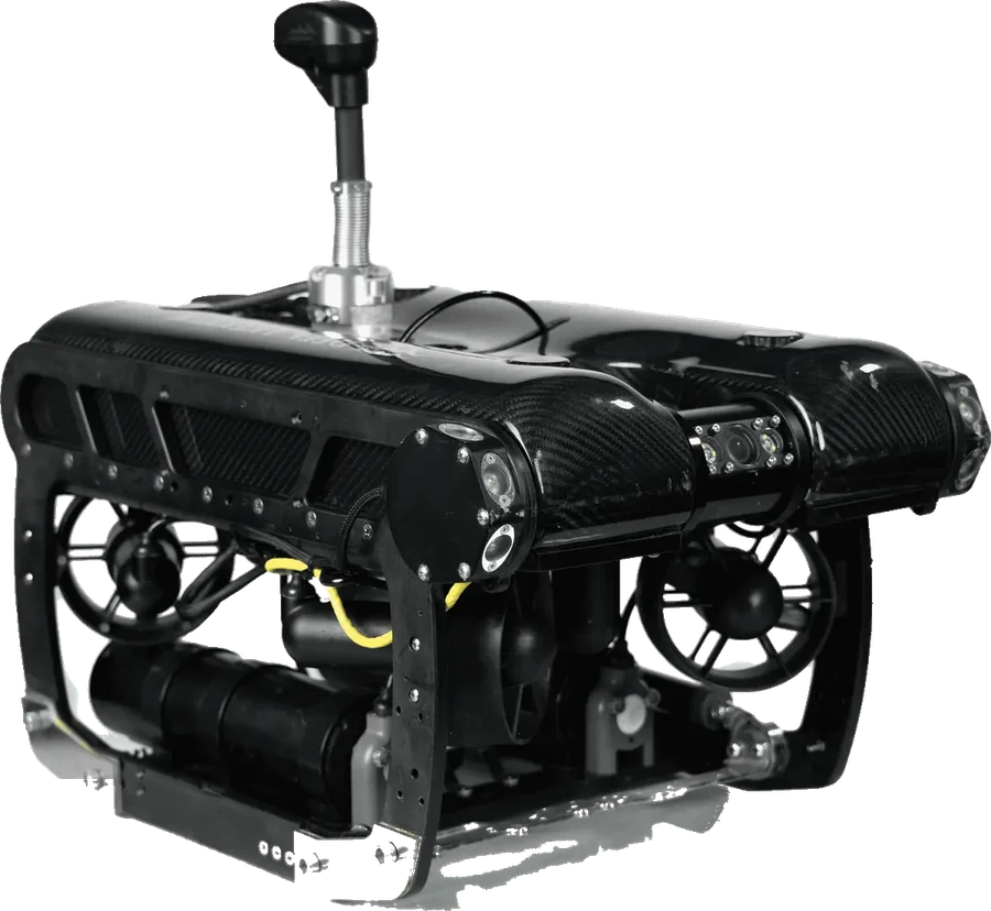 INSPECTION-CLASS ROV
Working with you
We work alongside you from the first conversation to the final report. Drawing on nearly two decades of subsea inspection, repair and project experience, we recommend the right approach for your site, objectives and budget, and explain what the findings mean for you.
We discuss what you need to know, review the site and constraints, and recommend the most effective method, equipment and level of reporting.
Your team can watch live and direct the inspection with us, and we advise on anything unexpected as it is found.
We interpret the findings and set out practical next steps: repair, monitoring, further investigation, or no action needed.
ROV operations explained
A remotely operated vehicle is an unmanned underwater vehicle, flown by a trained pilot from the surface. It is connected to the surface by a tether that carries power, control signals and live video, so everyone on site can see what the ROV sees, as it sees it.
A compact underwater platform with thrusters, a high-definition camera and lighting. Additional sensors and tools can be fitted to suit the task.
At the surface, the pilot flies the ROV from a controller with a live display. Video, depth and heading are recorded throughout the operation.
A supervisor plans and controls the operation, a pilot flies the vehicle, and a dedicated tether handler manages the tether at all times.
Services
Four core services, each planned around your site, your water conditions and the information you need at the end of the job.
Systematic, recorded survey of structures, seabed and lake bed to establish condition and record a baseline.
Slow, controlled inspection of specific components, with 4K video and stills of every point of interest.
Planned search patterns using sonar and DVL-aided navigation to find items underwater, log their position and support recovery.
ROV support for asset owners, marine contractors, engineers, surveyors and dive teams, putting live underwater information where it is needed.
Applications
ROV operations suit a wide range of coastal, marine and inland environments. Typical examples include:
Sea walls, breakwaters, groynes, revetments and coastal defences.
Condition · scour · toe erosion · armour displacementQuay walls, piles, fenders, slipways, lock gates and berths.
Wall condition · pile inspection · berth clearancePontoons, piles, mooring chains, sinkers and berths.
Mooring checks · chain wear · lost itemsHulls, running gear, rudders, sea chests and anodes.
Hull condition · fouling · damage surveyIntake towers, draw-off works, screens, spillways and upstream faces.
Intake inspection · screen condition · debrisRaw water intakes, outfalls, tanks, chambers and treatment structures.
Outfall survey · tank inspection · blockagesPiers, abutments, jetties and piled structures in rivers and estuaries.
Scour observation · pile conditionInland waters, leisure pools, test tanks and training facilities.
Leak investigation · condition · trainingCapability
Equipment is tailored to each client's requirements. We build the ROV spread, sensors and tooling around each project's depth, access, water conditions and deliverables. Our core inspection system is shown below, with further equipment available to suit each project.
Our core system
A portable, battery-powered inspection ROV with 4K video and six thrusters for precise, stable positioning close to structures.
Our PIVOT is upgraded beyond the base model, and every Tidal Robotics operation includes:
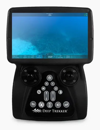
Handheld surface controller with a 7-inch display and onboard recording.
Manufacturer’s specifications for the PIVOT, with the 150 m tether as configured for Tidal Robotics. All-day operation is achieved by rotating charged batteries. Capability for each project depends on the equipment and configuration selected.
Advanced imaging
Beyond video, we capture measurable 3D models of underwater structures and see through water where cameras cannot. Together they turn an inspection into accurate, repeatable data.
Photogrammetry builds an accurate 3D model of a structure from hundreds of overlapping high-resolution images. Instead of a video you have to scrub through, you get a model you can rotate, measure and compare over time.
Many UK harbours, rivers and reservoirs have poor underwater visibility. Imaging sonar uses sound instead of light, producing a live image of the surroundings in turbid or dark water, well beyond the reach of the camera and lights.
What you receive
Every project ends with information you can act on, file and share. Measurements are taken against the ROV’s laser scaler, so sizes in your report are accurate rather than estimated.
Full 4K video of the operation, organised by location or asset.
Measurable photogrammetry models and orthomosaics of surveyed structures.
Key stills of findings, labelled with location, time and observation.
Scope, method, conditions, findings and recommendations in a clear, professional format.
Your team can watch the live feed on site and direct the inspection as it happens.
Reports are customised to each client’s requirements and budget, from a quick handover to a full engineering-grade record. Format, structure and asset references can follow your own templates and specifications.
Recorded video and key stills, with a short summary of what was seen. Fast turnaround at the lowest cost.
A structured written report for maintenance planning and records.
A full record for engineers, insurers and asset managers.
Approach
Every project follows the same five stages, from your first enquiry to the final report.
We agree the objectives, location, conditions and deliverables, and recommend the best approach for your budget.
A site-specific risk assessment and method statement (RAMS) is issued for your approval.
Equipment is checked and the team briefed with a toolbox talk on site.
The ROV is flown to the agreed plan, with the tether managed throughout and live video at the surface.
Footage, images and a written report are delivered in the agreed format.
Site-specific RAMS, a dedicated tether handler, clear stop-work authority and emergency arrangements agreed with the site owner.
We integrate with your site rules, permits and emergency plans, and coordinate with dive teams and other contractors on site.
Toolbox talks, daily progress records and a post-job close-out on every project, so you have a clear record of what was done and found.
Experience
Tidal Robotics is led by Ian Newton, a former commercial diver and dive supervisor who has managed subsea inspection, repair and construction projects in the UK, Europe, the Middle East, Central Asia and West Africa. That experience shapes how every ROV project is planned, run and reported.
Managing Director · ROV Supervisor
Client-side representative for a major energy operator on major capital projects and offshore construction.
UK inshore and onshore commercial diving operations, a platform hot-tap project in the Netherlands, an inspection, repair and maintenance (IRM) campaign on offshore platforms in Turkmenistan, and an FPSO mooring system replacement in West Africa.
Technical authority and tender support for offshore renewables and diving projects, and interface manager between commercial and project teams.
Ran five dive teams, two dive support vessels and two jack-up vessels on a field-wide IRM programme, coordinating vessel positioning and scheduling subsea works.
Led platform inspection campaigns (ACFM, flooded member detection, UT and CP surveys), jacket reinforcement, riser clamp installation, pipeline repair and CALM buoy inspection for international energy operators.
Inspection, repair, salvage and construction diving, including supervising underwater works on a major estuary bridge crossing in Scotland and a port development on the Thames, working alongside ROV and survey teams.
Projects Ian has managed or delivered during his career with diving and offshore contractors.
Three-month, £1m replacement of a ferry fendering system, delivered on time and within budget.
Six-week subsea intervention project addressing polluting wrecks off Plymouth.
Six-week, logistically complex renovation of marina piles.
Multi-platform inspection campaigns using CP, UT, flooded member detection and ACFM, plus semi-submersible inspection.
Major export pipeline damage rectification by sectional replacement, with flange and spool installation.
CALM buoy refurbishment and installation, buoy inspection, and SPM hose replacement for an FPSO connection.
Gas production platform hook-up using a hot-tap system, with tie-in and mattress installation.
28 km pipeline route clearance, lay support, debris removal, scour protection and closing spool tie-ins.
“Ian has consistently demonstrated exceptional skills in managing and delivering a diverse range of complex subsea and marine civil projects from inception to completion.”
“From board rooms to back decks Ian has always led with confidence that was backed up by hours of diligent information gathering.”
“He has excellent IT, interpersonal and multi-tasking skills, and can set, track and deliver complex project deliverables internally and for Clients.”
Full references available on request.
FAQ
Our core inspection system is rated to 305 m. In practice, most coastal, harbour and inland work is in much shallower water. We confirm the right equipment for your depth at the scoping stage.
Visibility affects camera range. We plan around it, use lighting to get the best images close to structures, and our ROV carries imaging sonar, so we can still navigate, search and locate targets when visibility is very poor.
Yes. We provide ROV support to asset owners, marine contractors, engineers, surveyors and dive teams, including pre-works surveys, live observation of underwater works and post-works checks. Operations are coordinated with your team under a combined plan.
Our ROV uses a doppler velocity log (DVL), GPS and dead-reckoning navigation to track its position underwater. Every finding, image and measurement can be tagged with its location, so it can be found again and compared on future surveys.
Our core system is battery powered, so no generator is required. Batteries are swapped in the field, so operations can run throughout the working day. We need safe access to the water’s edge and an agreed working area.
Many inspections are completed in a few hours on site. Larger surveys are planned in phases. We give a clear programme when we quote.
Yes. Every project has a site-specific risk assessment and method statement, issued for your approval before we attend.
Recorded video, annotated stills and a written report with findings and recommendations, in a format agreed at the start.
We are based in Weymouth, Dorset, and operate nationally across the UK. We mobilise to sites anywhere in the country.
About
Tidal Robotics Ltd is an ROV services company based in Weymouth, Dorset, led by Managing Director Ian Newton.
We deliver underwater survey, inspection, search and project support using inspection-class ROV systems, giving clients reliable, recorded information about assets and environments below the surface.
Ian brings nearly two decades of subsea experience as a commercial diver, dive supervisor, project manager and client representative, much of it on inspection, repair and maintenance work for international energy operators. He understands what asset owners and dive teams need from an underwater inspection, because he has been on both sides of it.
We operate UK-wide from our Weymouth base.
Our work is built on careful planning, safe operation and clear reporting, so clients can make confident decisions about maintenance, repair and further investigation.
Contact
Tell us what you need to see underwater, where it is and when. We will come back to you with options and a clear quote.